Water level monitoring isn’t just a technical procedure, it’s one of the most powerful tools we have to protect communities from the destructive force of water. When the rainy season arrives, rivers and creeks that were once calm can swell into threats, often without warning. But with the right systems in place, we don’t have to be caught off guard.
As the climate shifts and extreme weather events become more frequent, the ability to anticipate and react to rising water levels becomes important and urgent. We’ve seen it before: flash floods that sweep away bridges, landslides triggered by sudden river surges, and entire neighborhoods submerged overnight. And yet, in many regions, the infrastructure for water level monitoring is outdated, or worse, nonexistent.
Why monitoring river flow matters more than ever
When we talk about water level monitoring, we’re talking about more than numbers on a screen. We’re talking about real-time data that gives us eyes on rivers, streams, and critical points of runoff, especially during high-risk periods like the rainy season. It’s not just about how high the water is now; it’s about how fast it’s rising, how much pressure it’s building, and how it compares to historical patterns.
In places where annual floods are expected, we often assume that local knowledge is enough. But nature doesn’t always follow familiar rules. What was once a “typical” rainy season is now harder to predict. That’s why relying on continuous, precise data is the only way to adapt.
And here’s where water level monitoring becomes crucial not just for emergency response, but for long-term planning. It helps engineers design safer infrastructure, helps local governments plan evacuation zones, and gives disaster response teams the lead time they need to act before it’s too late.
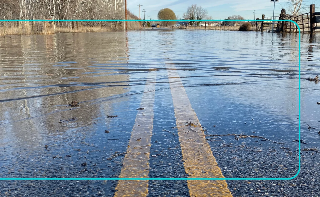
The cost of not knowing
When a river overflows and there’s no monitoring system in place, decisions are made in the dark. Roads close too late. Warnings come when people are already trapped. Losses add up in homes, in public works, in human lives.
The economic impact alone is staggering. According to FEMA, floods cost the U.S. over $8 billion annually in damage. But beyond the dollars are the irreversible losses of historical landmarks destroyed, crops wiped out, and above all, lives lost to a lack of information.
Many of these tragedies are preventable. Not all, of course, but a large percentage could be avoided or minimized through water level monitoring systems that track river flow in real time and alert communities as soon as danger begins to rise.

What continuous water level monitoring looks like
Real-time water level monitoring involves more than installing a sensor and checking in once in a while. Today’s systems offer high-frequency data collection, satellite transmission, and intelligent analytics that can detect patterns and anomalies before they escalate.
Modern sensors like the SOMMER RQ-30 ADMS, for example, offer non-contact radar-based measurement, meaning the system measures surface water velocity and calculates discharge without ever touching the water. This is a game-changer, especially in remote or high-risk areas where traditional monitoring stations are unsafe or hard to maintain.
By combining radar technology with integrated data loggers and real-time telemetry, the RQ-30 allows for constant monitoring with no physical interference in the stream. It’s durable, accurate even during sediment-heavy flow, and can be solar-powered, making it ideal for long-term deployment in any climate.
But more than its specs, what sets this kind of technology apart is what it enables: a clear picture of risk, updated minute by minute, accessible from any location.
Empowering communities with data, not assumptions
Too often, the communities most at risk from floods are also those with the fewest resources for prevention. Small towns, rural municipalities, and remote villages are frequently left with no warning system at all. Investing in water level monitoring isn’t just about modernizing infrastructure, it’s about decentralizing resilience.
When local teams can access their data, they don’t need to wait for top-down instructions. They can act. Whether that means closing a road, activating an emergency protocol, or issuing a local alert, information gives them back control.
It also allows collaboration across agencies, environmental departments, disaster relief teams, and transportation officials, all speaking the same language: data.
The technology exists. The time to use it is now.
There’s no shortage of advanced tools for water level monitoring today. What’s missing is the widespread implementation of these systems in areas that need them most. Part of that comes down to awareness, and part to budget priorities. But when you compare the cost of monitoring to the cost of rebuilding, the numbers speak for themselves.
Tools like the SOMMER RQ-30 ADMS, available through Inteccon, demonstrate what’s possible: continuous, reliable, low-maintenance monitoring of rivers, creeks, and flood-prone zones, all in real time.
It’s the kind of tech that doesn’t just support resilience. It makes it possible.
Conclusion
Water doesn’t wait. When rivers rise, when the ground can’t absorb another inch of rain, and when systems fail to warn us, the consequences are immediate and devastating.
But water level monitoring gives us time. Time to warn. Time to act. Time to protect what matters.
As we move deeper into an era of climatic uncertainty, the smartest step we can take is also one of the most practical: watch the water. Measure it. Understand it. And make decisions not based on fear, but on fact.
Because when we monitor water intelligently, we don’t just reduce the risk, we transform how we live with it.